Chassell, Kingsford under flood warnings tonight – danger through Tuesday – The Sturgeon River near Chassell – and the Menominee River affecting Dickinson and Menominee counties in U.P. and the WI border counties of Florence and Marinette Counties

URGENT URGENT URGENT URGENT U.P. Breaking News Bulletin – 4-29-18 – 10:38 p.m. ET 9:38 p.m. CT

Houghton County, Dickinson County and Menominee County Flood Warnings and Advisory for U.P. Rivers – Includes the Menominee River in Kingsford – and the Sturgeon River in Houghton County

Flood graphic.jpg

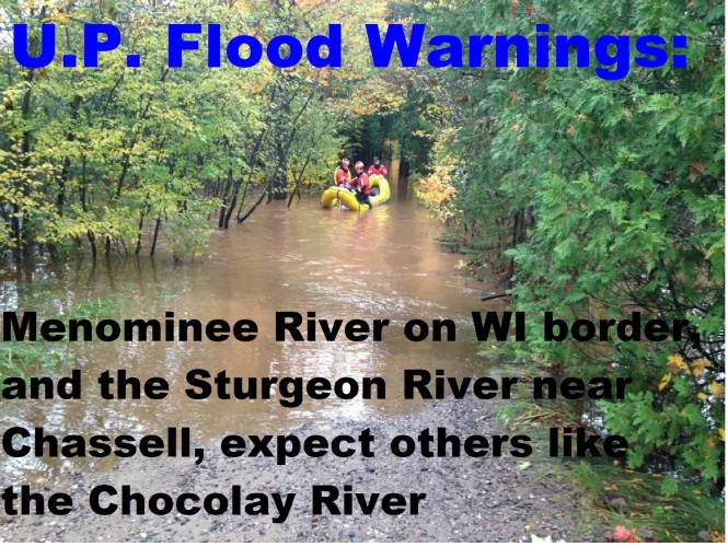
The Sturgeon and Menominee Rivers are at flood stage and beyond

By Greg Peterson
U.P. Breaking News
Owner, News Director
906-273-2433

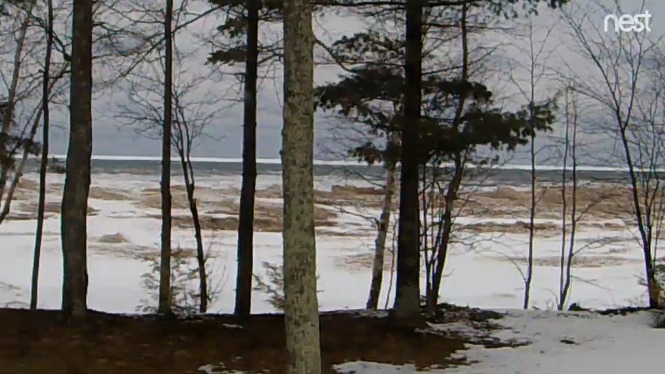
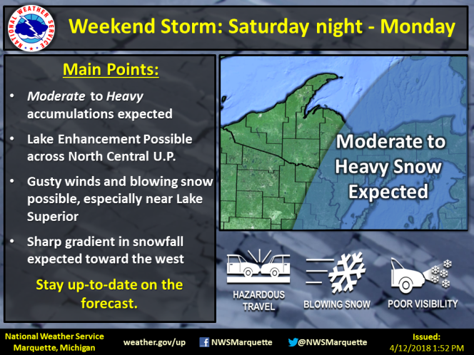
(Upper Peninsula of Michigan) – Snowmelt is causing real flooding issues and yet we are also have extreme wildfire danger.
Expect flooding and wildfires over the next few days.
U.P. under high fire danger warnings for wildfires – and flooding warnings and advisories due to rising rivers and snowmelt.
It gonna get bad tomorrow night and all day Monday!!!!
If you live next to a rising U.P. river has a fast action evacuation plan in place. Its a must.

Menominee River near Niagara affecting Dickinson…Menominee…
Florence and Marinette Counties

Menominee River near Vulcan affecting Dickinson…Menominee and
Marinette Counties

Flood Warnings:

Flood Statement
National Weather Service Marquette MI
854 PM EDT Sat Apr 28 2018

…The Flood Warning continues for the following rivers in Upper
Michigan…

Sturgeon River near Chassell affecting Houghton County

.River levels have stabilized on the Sturgeon River near Chassell
as the current level remains just below flood stage at 10.3 feet.
Snowmelt runoff should be minimal through Sunday morning as
temperatures remain cool. However, temperatures will rise rapidly
late Sunday and into early next week, allowing snowmelt runoff to
increase and river levels to rise again. There is still ample
snowpack in parts of the basin, especially on north aspects and
in heavily wooded areas.

PRECAUTIONARY/PREPAREDNESS ACTIONS…

Safety message…Even 6 inches of fast moving flood water can knock
you off your feet…and a depth of 2 feet will float your car. Never
try to walk…swim…or drive through such swift water. If you come
upon flood waters…stop…turn around and go another way.

additional weather and river information is available at
http://www.weather.gov/mqt

The next statement will be issued by Sunday morning.

&&

MIC061-291454-
/O.CON.KMQT.FL.W.0001.180429T0054Z-180501T2200Z/
/CLLM4.1.SM.180427T1100Z.180428T0000Z.180428T0116Z.UU/
854 PM EDT Sat Apr 28 2018

The Flood Warning continues for
The Sturgeon River near Chassell.
* until Tuesday evening.
* At 7:00 PM Saturday the stage was 10.3 feet.
* Flood stage is 10.5 feet.
* At 10.5 feet…The river begins to overflow onto Sturgeon River
Road…Rajala Road…and Aho Road.

——-
Flood Statement
National Weather Service Green Bay WI
925 PM CDT Sat Apr 28 2018

…The Flood Advisory continues for the Wisconsin River…

Wisconsin River at Merrill affecting Lincoln and Marathon Counties

Wisconsin River at Rothschild affecting Marathon County

Wisconsin River below Wisconsin Rapids affecting Wood County

Synoptic conditions continue to support high flows on area rivers and
streams.

PRECAUTIONARY/PREPAREDNESS ACTIONS…

Although below flood stage, flows are above normal and could be a
hazard to boaters and other recreational interests along the river.

&&

WIC069-073-290325-
/O.CON.KGRB.FL.Y.0007.000000T0000Z-180429T0258Z/
/RRLW3.N.SM.000000T0000Z.000000T0000Z.000000T0000Z.OO/
925 PM CDT Sat Apr 28 2018

The Flood Advisory continues for
The Wisconsin River at Merrill
* At 7:15 PM Saturday the stage was 8.6 feet.
* Flood stage is 11.0 feet.
* The river is forecast to slowly fall this weekend into next week.
* Impacts at 10.0 feet. There is minor lowland flooding.
Fast flows will continue.

&&

LAT…LON 4521 8970 4512 8957 4500 8958 4500 8967
4514 8972 4515 8971

$$

Flood Statement
National Weather Service Green Bay WI
925 PM CDT Sat Apr 28 2018

…The Flood Advisory continues for the Wisconsin River…

Wisconsin River at Merrill affecting Lincoln and Marathon Counties

Wisconsin River at Rothschild affecting Marathon County

Wisconsin River below Wisconsin Rapids affecting Wood County

Synoptic conditions continue to support high flows on area rivers and
streams.

PRECAUTIONARY/PREPAREDNESS ACTIONS…

Although below flood stage, flows are above normal and could be a
hazard to boaters and other recreational interests along the river.

&&

WIC073-290325-
/O.CON.KGRB.FL.Y.0008.000000T0000Z-180429T0258Z/
/ROTW3.N.SM.000000T0000Z.000000T0000Z.000000T0000Z.OO/
925 PM CDT Sat Apr 28 2018

The Flood Advisory continues for
The Wisconsin River at Rothschild
* At 8:00 AM Friday the stage was 21.6 feet.
* Flood stage is 25.0 feet.
* The river is forecast to slowly fall this weekend into next week.
* Impacts at 20.5 feet. There is widespread lowland flooding.
Fast flows will continue.

&&

LAT…LON 4489 8961 4478 8964 4469 8961 4469 8973
4477 8976 4489 8967

$$

Flood Statement
National Weather Service Green Bay WI
912 PM CDT Sat Apr 28 2018

…The National Weather Service in Green Bay has issued a Flood
Advisory for the Menominee River…

Menominee River near Kingsford affecting Dickinson…Florence and
Marinette Counties

Menominee River near Big Quinnesec Falls Dam affecting
Dickinson…Menominee…Florence and Marinette Counties

Synoptic conditions continue to support high flows on area rivers and
streams.

PRECAUTIONARY/PREPAREDNESS ACTIONS…

Although below flood stage, flows are above normal and could be a
hazard to boaters and other recreational interests along the river.

&&

MIC043-WIC037-075-301411-
/O.NEW.KGRB.FL.Y.0013.180429T0212Z-180430T1411Z/
/KFDM4.N.SM.000000T0000Z.000000T0000Z.000000T0000Z.OO/
912 PM CDT Sat Apr 28 2018

The National Weather Service in Green Bay has issued a
* Flood Advisory for
The Menominee River near Kingsford
* At 8:10 PM Saturday the flow was 5291 cfs.
* Impacts at 8000 cfs. Flows at this rate downstream from the
Kingsford dam may impact some shoreline structures.

&&

LAT…LON 4583 8811 4581 8806 4576 8806 4581 8817

$$

Flood Statement
National Weather Service Green Bay WI
912 PM CDT Sat Apr 28 2018

…The National Weather Service in Green Bay has issued a Flood
Advisory for the Menominee River…

Menominee River near Kingsford affecting Dickinson…Florence and
Marinette Counties

Menominee River near Big Quinnesec Falls Dam affecting
Dickinson…Menominee…Florence and Marinette Counties

Synoptic conditions continue to support high flows on area rivers and
streams.

PRECAUTIONARY/PREPAREDNESS ACTIONS…

Although below flood stage, flows are above normal and could be a
hazard to boaters and other recreational interests along the river.

&&

MIC043-109-WIC037-075-301411-
/O.NEW.KGRB.FL.Y.0014.180429T0212Z-180430T1411Z/
/BGQW3.N.SM.000000T0000Z.000000T0000Z.000000T0000Z.OO/
912 PM CDT Sat Apr 28 2018

The National Weather Service in Green Bay has issued a
* Flood Advisory for
The Menominee River near Big Quinnesec Falls Dam
* At 8:10 PM Saturday the flow was 5780 cfs.
* Impacts at 5000 cfs. While flooding is not expected…rivers flows
are high or expected to increase. Recreational interests should
monitor the river. Property owners adjacent to the river should
consider protecting shoreline equipment including docks piers and
boats.

&&

LAT…LON 4588 8811 4579 8790 4572 8790 4579 8819

$$

Flood Statement
National Weather Service Green Bay WI
906 PM CDT Sat Apr 28 2018

…The National Weather Service in Green Bay has issued a Flood
Advisory for the Menominee River…

Menominee River near Niagara affecting Dickinson…Menominee…
Florence and Marinette Counties

Menominee River near Vulcan affecting Dickinson…Menominee and
Marinette Counties

Menominee River near McAllister affecting Menominee and Marinette
Counties

Synoptic conditions continue to support high flows on area rivers and
streams.

PRECAUTIONARY/PREPAREDNESS ACTIONS…

Although below flood stage, flows are above normal and could be a
hazard to boaters and other recreational interests along the river.

&&

MIC043-109-WIC037-075-301406-
/O.NEW.KGRB.FL.Y.0010.180429T0206Z-180430T1849Z/
/NIAW3.N.SM.000000T0000Z.000000T0000Z.000000T0000Z.OO/
906 PM CDT Sat Apr 28 2018

The National Weather Service in Green Bay has issued a
* Flood Advisory for
The Menominee River near Niagara
* At 7:15 PM Saturday the stage was 9.7 feet.
* Flood stage is 13.0 feet.
* The river is forecast to reach maximum stage of 9.8 feet tomorrow
early afternoon.
* Impacts at 10.0 feet. Which is bankfull stage…there is flooding
of lowland. Piers gorge rapids downstream becoming active. High flows
will continue.

&&

LAT…LON 4588 8803 4582 8803 4579 8785 4569 8790
4575 8820 4587 8817

$$

Flood Statement
National Weather Service Green Bay WI
906 PM CDT Sat Apr 28 2018

…The National Weather Service in Green Bay has issued a Flood
Advisory for the Menominee River…

Menominee River near Niagara affecting Dickinson…Menominee…
Florence and Marinette Counties

Menominee River near Vulcan affecting Dickinson…Menominee and
Marinette Counties

Menominee River near McAllister affecting Menominee and Marinette
Counties

Synoptic conditions continue to support high flows on area rivers and
streams.

PRECAUTIONARY/PREPAREDNESS ACTIONS…

Although below flood stage, flows are above normal and could be a
hazard to boaters and other recreational interests along the river.

&&

MIC043-109-WIC075-301406-
/O.NEW.KGRB.FL.Y.0011.180429T0206Z-180430T1849Z/
/VLCM4.N.SM.000000T0000Z.000000T0000Z.000000T0000Z.OO/
906 PM CDT Sat Apr 28 2018

The National Weather Service in Green Bay has issued a
* Flood Advisory for
The Menominee River near Vulcan
* At 8:00 PM Saturday the stage was 10.6 feet.
* Flood stage is 15.0 feet.
* The river is forecast to reach maximum stage of 10.5 feet after
midnight tomorrow.
* Impacts at 12.0 feet. There is some minor flooding of adjacent
farmland and wooded lowland. High flows will continue.

&&

LAT…LON 4580 8784 4568 8772 4547 8775 4550 8787
4573 8790

$$

Flood Statement
National Weather Service Green Bay WI
906 PM CDT Sat Apr 28 2018

…The National Weather Service in Green Bay has issued a Flood
Advisory for the Menominee River…

Menominee River near Niagara affecting Dickinson…Menominee…
Florence and Marinette Counties

Menominee River near Vulcan affecting Dickinson…Menominee and
Marinette Counties

Menominee River near McAllister affecting Menominee and Marinette
Counties

Synoptic conditions continue to support high flows on area rivers and
streams.

PRECAUTIONARY/PREPAREDNESS ACTIONS…

Although below flood stage, flows are above normal and could be a
hazard to boaters and other recreational interests along the river.

See Lake Superior Crazy Wind-Driven Waves: U.P. Wind Damage Already Reported – Power and cable outages, wrecks, ferry service down – But Hold on to your hats because its two-day storm – dangerous driving and much more to come – We have your important links – and a concise summary of expected snow and ice totals

U.P. Breaking News Bulletin: – Updated 8:11 p.m. ET Saturday 4-14-18

Thank you to a friend for this video: Upper Harbor Breakwater at Presque Isle – Lake Superior Crazy Wind-Driven Waves on 4-14-18 – plus below that the latest forecast now saying up to 19 inches in some areas

——-

URGENT - WINTER WEATHER MESSAGE
National Weather Service Marquette MI
340 PM EDT Sat Apr 14 2018

MIZ010>012-151100-
/O.CON.KMQT.WS.W.0009.180415T0600Z-180416T0600Z/
Iron-Dickinson-Menominee-
Including the cities of Iron River, Iron Mountain, and Menominee
240 PM CDT Sat Apr 14 2018

...WINTER STORM WARNING REMAINS IN EFFECT FROM 1 AM SUNDAY TO
1 AM CDT MONDAY...

* WHAT...Heavy snow expected, with some mixed precipitation
  possible. Total snow accumulations of 12 to 16 inches and ice
  accumulations of a light glaze are expected.

* WHERE...Iron, Dickinson and Menominee Counties.

* WHEN...From 1 AM Sunday to 1 AM CDT Monday.

* ADDITIONAL DETAILS...Plan on difficult travel conditions. Winds
  gusting as high as 35 mph will cause areas of blowing and
  drifting snow, sharply reducing visibilities at times.

PRECAUTIONARY/PREPAREDNESS ACTIONS...

A Winter Storm Warning means significant amounts of snow, sleet
and ice will make travel very hazardous or impossible.

&&

$$

URGENT - WINTER WEATHER MESSAGE
National Weather Service Marquette MI
340 PM EDT Sat Apr 14 2018

MIZ007-013-014-085-151100-
/O.CON.KMQT.WS.W.0009.180415T0600Z-180416T0600Z/
Luce-Delta-Southern Schoolcraft-Northern Schoolcraft-
Including the cities of Newberry, Escanaba, Gladstone,
Manistique, and Seney
340 PM EDT Sat Apr 14 2018

...WINTER STORM WARNING REMAINS IN EFFECT FROM 2 AM SUNDAY TO
2 AM EDT MONDAY...

* WHAT...Heavy snow expected, with some mixed precipitation
  possible. Total snow accumulations of 7 to 14 inches, with
  locally higher amounts possible. Ice accumulations of a light
  glaze are expected.

* WHERE...Luce, Delta, Southern Schoolcraft and Northern
  Schoolcraft Counties.

* WHEN...From 2 AM Sunday to 2 AM EDT Monday.

* ADDITIONAL DETAILS...Plan on difficult travel conditions. Winds
  gusting as high as 35 mph will cause areas of blowing and
  drifting snow, sharply reducing visibilities at times.

PRECAUTIONARY/PREPAREDNESS ACTIONS...

A Winter Storm Warning means significant amounts of snow, sleet
and ice will make travel very hazardous or impossible.

&&

$$

URGENT - WINTER WEATHER MESSAGE
National Weather Service Marquette MI
340 PM EDT Sat Apr 14 2018

MIZ004>006-151100-
/O.CON.KMQT.WS.W.0009.180415T0600Z-180416T1200Z/
Baraga-Marquette-Alger-
Including the cities of L`Anse, Gwinn, Marquette, Grand Marais,
and Munising
340 PM EDT Sat Apr 14 2018

...WINTER STORM WARNING REMAINS IN EFFECT FROM 2 AM SUNDAY TO
8 AM EDT MONDAY...

* WHAT...Heavy snow expected. Total snow accumulations of 10 to 19
  inches, with locally higher amounts expected, especially in the
  higher terrain.

* WHERE...Baraga, Marquette and Alger Counties.

* WHEN...From 2 AM Sunday to 8 AM EDT Monday.

* ADDITIONAL DETAILS...Travel will be very difficult to
  impossible. Winds gusting as high as 40 mph will cause areas of
  blowing and drifting snow, sharply reducing visibilities at
  times.

PRECAUTIONARY/PREPAREDNESS ACTIONS...

A Winter Storm Warning means significant amounts of snow, sleet
and ice will make travel very hazardous or impossible.

&&

$$

URGENT - WINTER WEATHER MESSAGE
National Weather Service Marquette MI
340 PM EDT Sat Apr 14 2018

MIZ001>003-009-084-151100-
/O.CON.KMQT.WS.W.0009.180415T0600Z-180416T1200Z/
Keweenaw-Ontonagon-Northern Houghton-Gogebic-Southern Houghton-
Including the cities of Copper Harbor, Ontonagon, Houghton,
Hancock, Ironwood, Kenton, and Sidnaw
340 PM EDT Sat Apr 14 2018 /240 PM CDT Sat Apr 14 2018/

...WINTER STORM WARNING REMAINS IN EFFECT FROM 2 AM EDT /1 AM
CDT/ SUNDAY TO 8 AM EDT /7 AM CDT/ MONDAY...

* WHAT...Heavy snow and blowing snow expected. Total snow
  accumulations of 14 to 19 inches, with locally higher amounts
  possible.

* WHERE...Keweenaw, Ontonagon, Northern Houghton, Gogebic and
  Southern Houghton Counties.

* WHEN...From 2 AM EDT /1 AM CDT/ Sunday to 8 AM EDT /7 AM CDT/
  Monday.

* ADDITIONAL DETAILS...Travel will be very difficult to
  impossible. Winds gusting as high as 40 mph will cause areas of
  blowing and drifting snow, sharply reducing visibilities at
  times.

PRECAUTIONARY/PREPAREDNESS ACTIONS...

A Winter Storm Warning for snow and blowing snow means severe
winter weather conditions will make travel very hazardous or
impossible. If you must travel, keep an extra flashlight, food,
and water in your vehicle in case of an emergency.

&&

$$

——-

Update 1:50 p.m. ET Saturday

U.P. Breaking News Safety Advisory: Slippery ice at soon-to-open Marquette Meijer’s and everywhere, minor snowplow crash in Escanaba: 4-14-18 – 1:40 p.m.

Black ice and freezing rain warnings:
27-year-old pregnant woman was just taken by Marquette Township EMS ambulance to U.P. Health System – Marquette after she fell on her side at the Grocery Entrance of the new Meijer’s Store in Marquette Township, MI.

Meanwhile – cops hare been asked to make accident report in Escanaba, after a city plow and another truck nicked each other. Technically third gov. snowplow crash in past month.

——-

4-14-18 – 12:50 p.m. ET

Wind damage already reported – but hold on to your hats – because two day storm – much more to come – we have your important links – and a concise summary of expected snow and ice totals

International Bridge Cam Soo, MI.jpgU.P. wind damage just starting to come in – as cable and power outages reported in Houghton County area

Winter Storm Warning
Hazardous Weather Outlook
Gale Warning until April 16, 01:00 AM CDT
Heavy Freezing Spray Warning until April 14, 03:00 PM CDT
Lakeshore Flood Advisory in effect from April 14, 07:00 AM EDT until April 16, 12:00 AM EDT
snapshot

Upper Peninsula Summer’s Almost Here Snowstorm

By Greg Peterson
U.P. Breaking News
Owner, News Director
906-273-2433

(Upper Peninsula of Michigan) – Damages reports from the north, south, east and west ends of the Upper Peninsula, a wind-whipped snowstorm has causes significant power outages, sign ripped from ground, cable, wrecks and other issues in each corner of the U.P.

Very strong winds and a snowstorm are howling across the Upper Peninsula, causing ice issues on St. Mary’s River stopping some ferry service to eastern U.P. islands, ripped out a stop sign on the opposite side of the U.P. – and causes some power outages and trees down on power lines in Houghton plus deep snow is expected in some areas like Menominee where heavy snow turns to serious freezing rain on Sunday.

The 2018-2019 Lake Superior Shipping Season is underway and ships are hugging the north shore of Lake Superior (see graphic below).

*******Plus there is a heavy snow – show shovel heart attack danger warning – posted by the NWS in Negaunee Township (Scroll down to see photos and graphics).

Houghton CamMighty Mack CamHoughton Lift Bridge

The Neebis Island Ferry told Chippewa County 911 that they were down for a long time due to ice; not sure about other ferries.

Meanwhile on the opposite end of the U.P., Ironwood officials were called to a stop sign that was ripped out of the ground by the wind at the four-way stop intersection of McLeod Avenue and S. Lowell Street.

Numerous power and cable outages have been affecting Houghton County, as UPPCO told Houghton County 911 dispatchers that numerous reports of power problems have them busy across the Copper Country.

Before sunrise, Houghton Police were sent to the Delta Zeta Sorority at 1009 College Avenue in Houghton, MI.
The sorority has a unique warning system that blares if somehow the power is cut – as a loud alarm could be heard in the background when the police officer on scene radioed dispatchers at Houghton County 911.
The officer reported that homes on either side of the sorority house were also without power. Power lines have also been reported down in Sault Ste. Marie, MI.

  • In Menominee area, heavy snow late Saturday night and through Sunday with total snow accumulations from 10 to 14 inches. Afternoon/evening Sunday snow mixed with freezing rain leading to ice accumulations of up to one tenth of an inch

  • Total snow accumulations of 9 to 13 inches are expected, except 7 to 10 inches from Manistique to Newberry

  • In Dickinson and Iron counties Total snow accumulations of 10 to 14 inches are expected

  • In Marquette County, heavy snow expected with the heaviest snowfall occurring during the day Sunday. Total snow accumulations of 12 to 16 inches – greatest in the higher terrain from just south and west of Marquette into the Huron Mountains

  • In Keweenaw, Ontonagon, Northern Houghton, Gogebic and Southern Houghton counties – heavy snow and blowing snow with total snow accumulations of 9 to 13 inches are expected

Sat Storm Gale Flag GraphicNWS Map Storm WarningSat storm heavy snow shovel graphicSat storm graphicEagle Harbor 2Ontonagon camMarine TrafficShips at seaEagle Harbor

Marquette National Weather Service updates warning this morning – Black Ice in some areas; 10 inches of snow with major blowing and drifting, dangerous driving; Western Lake Superior gusts nearly 50 mph, waves 15-feet

URGENT URGENT  – Just updated from NWS – U.P. Breaking News and Weather Bulletin: – 4-13-18 – 4:47 a.m. ET

New NWS special snowstorm statements issued this morning: U.P. Winter winds down with a weekend punch – lots of  black ice, snow, wind, waves and slippery driving

NWS Graphic 2

By Greg Peterson
U.P. Breaking News
Owner, News Director
906-273-2433

(Upper Peninsula of Michigan including Lake Superior) – A major snowstorm will pass through the U.P. this weekend – making driving hazardous with heavy, drifting and blowing snow.
Black ice is a danger the entire weekend including this morning.
A large storm system is moving through the Great Lakes this weekend.
And you would not want to be out in western Lake Superior with 15-foot waves and gusts to nearly 50 mph.

Important NWS Marquette links:
https://www.weather.gov/mqt/
Winter Storm Watch in effect from Saturday, April 14, 7:00 PM CDT until Monday, April 16, 1:00 AM CDT
Winter Storm Watch in effect from tonight Fri., April 13, 8:00 PM EDT until Sat., April 14, 2:00 PM EDT
Winter Storm Warning
Winter Storm Watch
Special Weather Statement
Gale Warning
NWS Marquette Spring 2018 Weather Presentations
Michigan Severe Weather Awareness Week April 8-14

Winter Storm Watch

URGENT - WINTER WEATHER MESSAGE
National Weather Service Marquette MI
427 AM EDT Fri Apr 13 2018

MIZ012-131630-
/O.UPG.KMQT.WS.A.0006.180414T0000Z-180414T1800Z/
/O.NEW.KMQT.WW.Y.0022.180414T0000Z-180414T1200Z/
/O.NEW.KMQT.WS.A.0007.180415T0000Z-180416T0600Z/
Menominee-
Including the city of Menominee
327 AM CDT Fri Apr 13 2018

...WINTER WEATHER ADVISORY IN EFFECT FROM 7 PM THIS EVENING TO
7 AM CDT SATURDAY...
...WINTER STORM WATCH IN EFFECT FROM SATURDAY EVENING THROUGH
LATE SUNDAY NIGHT...

* WHAT...Snow expected tonight. Total snow accumulations of 1 to 3
  inches, with localized amounts up to 5 inches, are expected
  tonight. Saturday night through Sunday evening, heavy snow is
  possible. Total snow accumulations of 8 inches or more are
  possible. The snow may mix with freezing rain Sunday night,
  leading to a light glaze of ice.

* WHERE...Menominee County.

* WHEN...For the Winter Weather Advisory, from 7 PM this evening
  to 7 AM CDT Saturday. For the Winter Storm Watch, from
  Saturday evening through late Sunday night.

* ADDITIONAL DETAILS...Plan on slippery road conditions and
  reduced visibilities at times tonight. Plan on difficult travel
  conditions Saturday night through Sunday night. Winds gusting
  as high as 35 mph could cause areas of blowing and drifting
  snow.

PRECAUTIONARY/PREPAREDNESS ACTIONS...

A Winter Weather Advisory for snow means periods of snow will
cause primarily travel difficulties. Expect snow covered roads
and limited visibilities, and use caution while driving.

A Winter Storm Watch means there is potential for significant
snow, sleet or ice accumulations that may impact travel. Continue
to monitor the latest forecasts.
URGENT - WINTER WEATHER MESSAGE
National Weather Service Marquette MI
427 AM EDT Fri Apr 13 2018

MIZ007-010-085-131630-
/O.NEW.KMQT.WS.A.0007.180415T0000Z-180416T0600Z/
Luce-Iron-Northern Schoolcraft-
Including the cities of Newberry, Iron River, and Seney
427 AM EDT Fri Apr 13 2018 /327 AM CDT Fri Apr 13 2018/

...WINTER STORM WATCH IN EFFECT FROM SATURDAY EVENING THROUGH
LATE SUNDAY NIGHT...

* WHAT...Heavy snow possible. Total snow accumulations of 8 or
  more inches are possible. The snow may mix with freezing rain
  from Seney eastward Sunday night, which may create a thin glaze
  of ice.

* WHERE...Luce, Iron and Northern Schoolcraft Counties.

* WHEN...From Saturday evening through late Sunday night.

* ADDITIONAL DETAILS...Plan on difficult travel conditions.
  Winds gusting as high as 35 mph could cause patchy blowing and
  drifting snow.

PRECAUTIONARY/PREPAREDNESS ACTIONS...

A Winter Storm Watch means there is potential for significant
snow, sleet or ice accumulations that may impact travel. Continue
to monitor the latest forecasts.

Winter Storm Watch

URGENT – WINTER WEATHER MESSAGE
National Weather Service Marquette MI
406 PM EDT Thu Apr 12 2018

MIZ011>014-131000-
/O.NEW.KMQT.WS.A.0006.180414T0000Z-180414T1800Z/
Dickinson-Menominee-Delta-Southern Schoolcraft-
Including the cities of Iron Mountain, Menominee, Escanaba,
Gladstone, and Manistique
406 PM EDT Thu Apr 12 2018 /306 PM CDT Thu Apr 12 2018/

…WINTER STORM WATCH heavy IN EFFECT FROM FRIDAY EVENING THROUGH
SATURDAY AFTERNOON…

* WHAT…Heavy snow possible. Total snow accumulations of 6 inches
or more are possible. The most snow will occur south of US-2.
The snow may mix with rain and sleet early on Friday evening.

* WHERE…Dickinson, Menominee, Delta and Southern Schoolcraft
Counties.

* WHEN…From Friday evening through Saturday afternoon.

* ADDITIONAL DETAILS…Plan on difficult travel conditions.
Significant reductions in visibility are possible due to blowing
and drifting snow.

PRECAUTIONARY/PREPAREDNESS ACTIONS…

A Winter Storm Watch means there is potential for significant
snow, sleet or ice accumulations that may impact travel. Continue
to monitor the latest forecasts.
JLA

Special Weather Statement

Special Weather Statement
National Weather Service Marquette MI
428 PM EDT Thu Apr 12 2018

MIZ011>014-131000-
Dickinson-Menominee-Delta-Southern Schoolcraft-
Including the cities of Iron Mountain, Menominee, Escanaba,
Gladstone, and Manistique
428 PM EDT Thu Apr 12 2018 /328 PM CDT Thu Apr 12 2018/

…ANOTHER SYSTEM MAY BRING MORE SNOW LATER THIS WEEKEND…

After the first system producing the potential heavy snow over
south central Upper Michigan Friday into Saturday morning exits
later Saturday, expect another round of moderate to heavy snow to
return to the area Saturday night through Sunday night as a strong
low pressure system lifts across the Great Lakes. Expect snow
amounts Saturday night through Sunday night to range from 5 to 10
inches, heaviest across the east half of Upper Michigan. Locally
higher amounts may occur. The most snow will fall late Saturday
night through Sunday evening. There is still uncertainty on the
track of the storm and these snow totals for Saturday night into
Sunday night may change in the coming days. In addition to the
snow, there could be areas of blowing and drifting snow,
especially later in the weekend.

Please continue to monitor later statements and forecasts for the
latest details concerning this late season winter weather.
URGENT – MARINE WEATHER MESSAGE
National Weather Service Marquette MI
1033 PM EDT Thu Apr 12 2018

LMZ221-248-250-131045-
/O.CON.KMQT.GL.W.0020.180413T1800Z-180415T1200Z/
Green Bay North of line from Cedar River MI to Rock Island
Passage-Seul Choix Point to Point Detour MI-
5NM East of a line from Fairport MI to Rock Island Passage-
1033 PM EDT Thu Apr 12 2018

…GALE WARNING REMAINS IN EFFECT FROM 2 PM FRIDAY TO 8 AM EDT
SUNDAY…

A Gale Warning remains in effect from 2 PM Friday to 8 AM EDT
Sunday.

* WIND AND WAVES DURING THE GALE WARNING…Expect sustained
winds of up to 31 knots from the northeast, with gusts up to
42 knots. The largest expected significant waves will be 10
feet with a maximum wave height of up to 15 feet possible.

* TIMING…The maximum winds are expected around 10 AM EDT
Saturday with the largest waves expected around 10 PM EDT
Saturday.

Please see the latest marine forecasts for more detailed
information.

PRECAUTIONARY/PREPAREDNESS ACTIONS…

A Gale Warning means winds of 34 to 47 knots are imminent or
occurring. Operating a vessel in gale conditions requires
experience and properly equipped vessels. It is highly
recommended that mariners without the proper experience seek safe
harbor prior to the onset of gale conditions.

Special Weather Statement
National Weather Service Marquette MI
428 PM EDT Thu Apr 12 2018

MIZ001>007-009-010-084-085-131000-
Keweenaw-Ontonagon-Northern Houghton-Baraga-Marquette-Alger-Luce-
Gogebic-Iron-Southern Houghton-Northern Schoolcraft-
Including the cities of Copper Harbor, Ontonagon, Houghton,
Hancock, L`Anse, Gwinn, Marquette, Grand Marais, Munising,
Newberry, Ironwood, Iron River, Kenton, Sidnaw, and Seney
428 PM EDT Thu Apr 12 2018 /328 PM CDT Thu Apr 12 2018/

…ACTIVE WINTER WEATHER INTO THE WEEKEND…

A narrow swath of heavy wet snow is expected to develop over
portions of southern Upper Michigan Friday into Friday night out
ahead of a strong deepening low over the central Plains. It still
looks like the heavier snow will stay south of north central Upper
Michigan. Expect snow amounts Friday into Saturday morning to
range from less than 1 inch on the Keweenaw, to 1 to 3 inches
along the rest of Lake Superior, including at Ironwood, Marquette
and Munising, and to 2 to 6 inches over south central Upper
Michigan, heaviest south of US-2. This first round of snow will
end on Saturday.

Another round of moderate to heavy snow is expected Saturday night
through Sunday night as the main low pressure system lifts across
the Great Lakes. Expect snow amounts Saturday night through Sunday
night to range from 5 to 10 inches, heaviest across the east half
of Upper Michigan. Locally higher amounts may occur. The most snow
will fall late Saturday night through Sunday evening. There is
still uncertainty on the track of the storm and these snow totals
may change in the coming days. In addition to the snow, there
could be significant blowing and drifting snow, especially closer
to Lake Superior late in the weekend.

Please continue to monitor later statements and forecasts for the
latest details concerning this late season winter weather.

NWS Graphic 1NWS Graphic 2

URGENT URGENT URGENT URGENT – 1-23-18 – 12:45 a.m. – Two U.P. police agencies have some of their computers fried – Marquette Police Dept. headquarters and entire Dickinson County E-911 Center – that dispatches for Iron Mountain Police and many agencies – Both communication centers fill with smoke almost simultaneously – during snowstorm; This weekend hospital electrical system fire reported

U.P. Breaking News Bulletin: 1-23-18 12:45 a.m. ET

Firefighters called to smoke-filled Marquette Police Headquarters and the entire Enhanced 911 Dispatch Center in Iron Mountain – that dispatches for all agencies – as electrical systems fry

Marquette Police HQ – and the 911 center in Iron Mountain serving all Dickinson County – both fill with smoke during snowstorm

By Greg Peterson
U.P. Breaking News
Owner, News Director
906-273-2433

(Upper Peninsula of Michigan) – You don’t often hear the police call for firefighters at the cop HQ or 911 – but it happened twice almost simultaneously this morning in the U.P. of Michigan.

Marquette firefighters are on the scene of an apparent electrical fire at the Marquette Police Headquarters.

Meanwhile – same thing was just reported at the Enhanced 911 Dickinson County Dispatch Center – located in the county building in Iron Mountain, MI.

A dispatcher in Iron Mountain said their entire system went down. Dickinson County 911 was filled with smoke – plus electronics are fried from computers to LEIN.

Marquette PD reported its problem about two minutes before Iron Mountain PD but could have been simultaneously.

Are they related due to timing and/or weather. If they are not related to either – then its a coincidence involving lotto type odds.

“The fire department is headed your way,” said a 911 dispatcher to a police official at the Marquette Police Headquarters.

The problem is “smoke coming out of their main frame computer room,” a dispatcher told firefighters in Marquette.

Not clear if its weather-related. No injuries reported.

Only two days ago firefighters rushed to a U.P. hospital hecause of an active electrical fire.

Iron Mountain firefighters were called Saturday night to the Dickinson County Memorial Hospital.
An “active electrical fire” was found in the rear of the hospital. No Injuries reported.

Meanwhile – the raging snowstorm has made driving inadvisable through at least tomorrow (Tuesday) afternoon. The storm has already caused several rollovers/accidents. Plus power outages reported in some areas.

Latest just issued by NWS Office Negaunee Township: A White Christmas – Good Grief – plus lake-effect snow will continue to hammer those in the snowbelt areas – If you can’t remember to drive with care – think of this – turning “Ho Ho Ho” into “Slow Slow Slow”

U.P. Breaking News Weather and Traffic Advisory – 6:40 a.m. ET 5:40 CT

MTI Web Cam 12-25-17 Campus Aerial

MTU Webcam  Campus Aerial
A view of campus from the Mechanical Engineering and Engineering Mechanics Building.

2017 Christmas Day – Cold and snow are here to stay

Even SUVs in Marquette and Chippewa County – slide off road – in big way

Latest from NWS in Negaunee Township, MI and links that always have updated info

By Greg Peterson
U.P. Breaking News
Owner, News Director
906-273-2433

Already this morning there have been numerous vehicle sliding off U.P. roads including SUVs .

Please drive slow – slow – slow – as you visit friends/relatives homes today.

A Jeep went flying off CR 553 near Marquette Mountain.

Then there was the Dodge Durango that flew 200 feet of a road in Chippewa County – not pleasing to wrecker drivers or cops.

Winter Storm Warning

Gale Warning

Wind Chill Warning

Winter Weather Advisory

Small Craft Advisory

Heavy Freezing Spray Warning

Wind Chill Advisory


MTU Web Cam 12-25-17 Portage Lift Bridge

Houghton-Hancock Lift Bridge from MTU webcam (we love their live cams)

MTU Web Cam 12-25-17 Keweenaw Waterway West

MTU Webcam  Keweenaw Waterway: West
A view of the Keweenaw Waterway looking west.


EXPECT BITTER COLD WIND CHILLS THROUGH MIDWEEK.

URGENT - WINTER WEATHER MESSAGE
National Weather Service Marquette MI
444 AM EST Mon Dec 25 2017

MIZ006-007-251745-
/O.CON.KMQT.WS.W.0010.000000T0000Z-171227T0000Z/
Alger-Luce-
Including the cities of Grand Marais, Munising, and Newberry
444 AM EST Mon Dec 25 2017

...WINTER STORM WARNING REMAINS IN EFFECT UNTIL 7 PM EST
TUESDAY...

* WHAT...Heavy lake effect snow occurring. Snow will be especially
  heavy through this morning. Plan on difficult travel conditions.
  Total snow accumulations around 1 foot are expected through
  tonight from around Munising to Grand Marais and across northern
  Luce county, including at Pine Stump Junction. Snow amounts of 5
  to 8 inches are expected near Newberry, and amounts of 2 inches
  or less will occur over western Alger county, including at
  Trenary. Heavy snow with additional accumulations will continue
  Tuesday, especially near Lake Superior.

* WHERE...Alger and Luce Counties.

* WHEN...Until 7 PM EST Tuesday.

* ADDITIONAL DETAILS...Winds gusting as high as 35 mph will
  cause areas of blowing and drifting snow. Cold wind chills as
  low as 25 below zero will cause frostbite in as little as 30
  minutes to exposed skin.

PRECAUTIONARY/PREPAREDNESS ACTIONS...

A Winter Storm Warning for heavy lake effect snow means
significant amounts of lake effect snow are forecast that will
make travel very hazardous or impossible. If you must travel,
keep an extra flashlight, food, and water in your vehicle in case
of an emergency.

$$

URGENT - WINTER WEATHER MESSAGE
National Weather Service Marquette MI
444 AM EST Mon Dec 25 2017

MIZ001-003-251745-
/O.EXB.KMQT.WW.Y.0041.171226T0000Z-171226T1800Z/
/O.CON.KMQT.WS.W.0010.000000T0000Z-171226T0000Z/
Keweenaw-Northern Houghton-
Including the cities of Copper Harbor, Houghton, and Hancock
444 AM EST Mon Dec 25 2017

...WINTER STORM WARNING REMAINS IN EFFECT UNTIL 7 PM EST THIS
EVENING...
...WINTER WEATHER ADVISORY IN EFFECT FROM 7 PM THIS EVENING TO
1 PM EST TUESDAY...

* WHAT...Heavy lake effect snow occurring. Plan on difficult
  travel conditions. For today, additional snow accumulations of 3
  to 5 inches, with localized amounts up to 8 inches, are
  expected. For tonight, additional snow accumulations of 2 to 4
  inches, with localized amounts up to 7 inches, are expected.

* WHERE...Keweenaw and Northern Houghton Counties.

* WHEN...For the Winter Storm Warning, until 7 PM EST this
  evening. For the Winter Weather Advisory, from 7 PM this
  evening to 1 PM EST Tuesday.

* ADDITIONAL DETAILS...Winds gusting as high as 35 mph will cause
  areas of blowing and drifting snow, especially today. Cold wind
  chills as low as 30 below zero will cause frostbite in as
  little as 30 minutes to exposed skin.

PRECAUTIONARY/PREPAREDNESS ACTIONS...

A Winter Storm Warning for heavy lake effect snow means
significant amounts of lake effect snow are forecast that will
make travel very hazardous or impossible. If you must travel,
keep an extra flashlight, food, and water in your vehicle in case
of an emergency.

A Winter Weather Advisory for lake effect snow means lake effect
snow is forecast that will make travel difficult in some areas.
Use caution when traveling.

$$

URGENT - WINTER WEATHER MESSAGE
National Weather Service Marquette MI
444 AM EST Mon Dec 25 2017

MIZ085-251745-
/O.UPG.KMQT.WW.Y.0041.171225T1200Z-171227T0000Z/
/O.EXA.KMQT.WS.W.0010.000000T0000Z-171227T0000Z/
Northern Schoolcraft-
Including the city of Seney
444 AM EST Mon Dec 25 2017

...WINTER STORM WARNING IN EFFECT UNTIL 7 PM EST TUESDAY...

* WHAT...Heavy lake effect snow occurring. Snow will be especially
  heavy through this morning. Plan on difficult travel conditions.
  Additional snow accumulations of 9 to 13 inches, with localized
  amounts up to 17 inches, are expected through tonight, except
  near Steuben where an inch or less of snow is expected.
  Additional accumulations will occur on Tuesday.

* WHERE...Northern Schoolcraft County.

* WHEN...Until 7 PM EST Tuesday.

* ADDITIONAL DETAILS...Winds gusting as high as 30 mph will cause
  areas of blowing and drifting snow. Cold wind chills as low as
  30 below zero late this afternoon through Tuesday morning will
  cause frostbite in as little as 30 minutes to exposed skin.

PRECAUTIONARY/PREPAREDNESS ACTIONS...

A Winter Storm Warning for heavy lake effect snow means
significant amounts of lake effect snow are forecast that will
make travel very hazardous or impossible. If you must travel,
keep an extra flashlight, food, and water in your vehicle in case
of an emergency.

“Difficult Travel” – Heavy Lake Effect snow impacting portions of US-41, M-28, M- 35 and M-94 – Winter Storm Warning continues today: The big 2017 24-hour Upper Peninsula snowstorm goes through 7 p.m. ET tonight – as up to heavy lake-effect snow, 40 mile per hour winds, huge Lake Superior waves and terrible driving – prepare for school and other closings on Tuesday

Happening now – U.P. Breaking News Weather Bulletin 12-12-17 5:05 a.m. ET

Updated forecasts released this morning:

https://radar.weather.gov/radar.php?rid=mqt

Lake Superior waves this morning caused  closing of Lakeshore Boulevard in Marquette as water from crashing waves and debris is washing onto the road.

Waves will pound Alger County shoreline today.

Up to 11 more inches of snow for some lake-effect snowstorm areas

Heavy lake effect snow occurring. Plan on difficult travel conditions, including during the morning commute today.

Additional snow accumulations of 3 to 7 inches, except 7 to 11 inches from near Harvey through Skandia to Carlshend and McFarland are expected through this evening. Locations to the south and west of Champion to Negaunee and Gwinn will see snow totals of 1 to 4 inches through this evening.

High winds and heavy snow impacting portions of US-41, M-28, M- 35 and M-94,

Winter Storm Warning

URGENT - WINTER WEATHER MESSAGE
National Weather Service Marquette MI
434 AM EST Tue Dec 12 2017

MIZ005-121900-
/O.CON.KMQT.WS.W.0007.000000T0000Z-171213T0000Z/
Marquette-
Including the cities of Gwinn and Marquette
434 AM EST Tue Dec 12 2017

...WINTER STORM WARNING REMAINS IN EFFECT UNTIL 7 PM EST THIS
EVENING...

* WHAT...Heavy lake effect snow occurring. Plan on difficult
  travel conditions, including during the morning commute today.
  Additional snow accumulations of 3 to 7 inches, except 7 to 11
  inches from near Harvey through Skandia to Carlshend and
  McFarland are expected through this evening. Locations to the
  south and west of Champion to Negaunee and Gwinn will see snow
  totals of 1 to 4 inches through this evening.

* WHERE...Marquette County. Impacting portions of US-41, M-28, M-
  35 and M-94, especially south and east of Marquette.

* WHEN...Until 7 PM EST Tuesday.

* ADDITIONAL DETAILS...Winds gusting as high as 30 mph will cause
  considerable blowing and drifting snow through late this
  morning. This will lead to occasional white-out conditions,
  especially along M-28 between Marquette and Munising.

PRECAUTIONARY/PREPAREDNESS ACTIONS...

A Winter Storm Warning for heavy lake effect snow means
significant amounts of lake effect snow are forecast that will
make travel very hazardous or impossible. If you must travel,
keep an extra flashlight, food, and water in your vehicle in case
of an emergency.

$$


Hazardous Weather Outlook

Hazardous Weather Outlook
National Weather Service Marquette MI
433 AM EST Tue Dec 12 2017

MIZ001>007-009>014-084-085-131200-
Keweenaw-Ontonagon-Northern Houghton-Baraga-Marquette-Alger-Luce-
Gogebic-Iron-Dickinson-Menominee-Delta-Southern Schoolcraft-
Southern Houghton-Northern Schoolcraft-
433 AM EST Tue Dec 12 2017 /333 AM CST Tue Dec 12 2017/

This Hazardous Weather Outlook is for portions of western Upper
Michigan and central Upper Michigan.

.DAY ONE...Today and Tonight

Occasional white-out conditions due to falling and blowing snow, and
additional accumulating snow expected through today and will lead
to difficult travel conditions across eastern Marquette,
northeastern Delta, and much of Alger counties. Especially along
the US-41 corridor in and south of the city of Marquette, and
adjacent highways primarily east of M-553. Across the west and far
east, hazardous travel will still be possible with light snow
accumulations through today. See the latest Winter Weather Message
for further details.

Large waves along the Lake Superior shoreline in Alger county will
continue through the mid morning hours. This will lead to minor
beach erosion and lakeshore flooding. See the latest Lakeshore
Hazard Message for further details.

.DAYS TWO THROUGH SEVEN...Wednesday through Monday

Accumulating lake effect snow is possible in the northeast wind
snow belts on Wednesday afternoon and evening. Additional accumulating
lake effect snow is on the way through the end of the week.

.SPOTTER INFORMATION STATEMENT...

Weather spotters are encouraged to submit reports of snowfall and
low visibilities to the National Weather Service in Marquette.
The public may also submit reports through our webpage, Facebook
page or on Twitter.

$$

Hazardous Weather Outlook

Hazardous Weather Outlook
National Weather Service Marquette MI
433 AM EST Tue Dec 12 2017

MIZ001>007-009>014-084-085-131200-
Keweenaw-Ontonagon-Northern Houghton-Baraga-Marquette-Alger-Luce-
Gogebic-Iron-Dickinson-Menominee-Delta-Southern Schoolcraft-
Southern Houghton-Northern Schoolcraft-
433 AM EST Tue Dec 12 2017 /333 AM CST Tue Dec 12 2017/

This Hazardous Weather Outlook is for portions of western Upper
Michigan and central Upper Michigan.

.DAY ONE...Today and Tonight

Occasional white-out conditions due to falling and blowing snow, and
additional accumulating snow expected through today and will lead
to difficult travel conditions across eastern Marquette,
northeastern Delta, and much of Alger counties. Especially along
the US-41 corridor in and south of the city of Marquette, and
adjacent highways primarily east of M-553. Across the west and far
east, hazardous travel will still be possible with light snow
accumulations through today. See the latest Winter Weather Message
for further details.

Large waves along the Lake Superior shoreline in Alger county will
continue through the mid morning hours. This will lead to minor
beach erosion and lakeshore flooding. See the latest Lakeshore
Hazard Message for further details.

.DAYS TWO THROUGH SEVEN...Wednesday through Monday

Accumulating lake effect snow is possible in the northeast wind
snow belts on Wednesday afternoon and evening. Additional accumulating
lake effect snow is on the way through the end of the week.

.SPOTTER INFORMATION STATEMENT...

Weather spotters are encouraged to submit reports of snowfall and
low visibilities to the National Weather Service in Marquette.
The public may also submit reports through our webpage, Facebook
page or on Twitter.

$$


Winter Storm Warning

URGENT - WINTER WEATHER MESSAGE
National Weather Service Marquette MI
434 AM EST Tue Dec 12 2017

MIZ005-121900-
/O.CON.KMQT.WS.W.0007.000000T0000Z-171213T0000Z/
Marquette-
Including the cities of Gwinn and Marquette
434 AM EST Tue Dec 12 2017

...WINTER STORM WARNING REMAINS IN EFFECT UNTIL 7 PM EST THIS
EVENING...

* WHAT...Heavy lake effect snow occurring. Plan on difficult
  travel conditions, including during the morning commute today.
  Additional snow accumulations of 3 to 7 inches, except 7 to 11
  inches from near Harvey through Skandia to Carlshend and
  McFarland are expected through this evening. Locations to the
  south and west of Champion to Negaunee and Gwinn will see snow
  totals of 1 to 4 inches through this evening.

* WHERE...Marquette County. Impacting portions of US-41, M-28, M-
  35 and M-94, especially south and east of Marquette.

* WHEN...Until 7 PM EST Tuesday.

* ADDITIONAL DETAILS...Winds gusting as high as 30 mph will cause
  considerable blowing and drifting snow through late this
  morning. This will lead to occasional white-out conditions,
  especially along M-28 between Marquette and Munising.

PRECAUTIONARY/PREPAREDNESS ACTIONS...

A Winter Storm Warning for heavy lake effect snow means
significant amounts of lake effect snow are forecast that will
make travel very hazardous or impossible. If you must travel,
keep an extra flashlight, food, and water in your vehicle in case
of an emergency.

$$


12-11-17 7:40 p.m. ET

National Weather Service Office for Marquette, MI:
Travel conditions will deteriorate rapidly across eastern Marquette county and much of Alger county during the overnight hours, with white-out conditions possible at times along with significant snowfall

Updated special weather advisories for U.P. by NWS in Negaunee Township – calls for deep snow, white-out conditions, 40 mile per hour winds and generally terrible driving

By Greg Peterson
Upper Peninsula Breaking News
Owner, News Director
906-273-2433

(Upper Peninsula of Michigan) – For the next 24-hours heavy lake effect snow will pound many areas of the U.P. – and creating deadly driving conditions.

Numerous power outages have been reported in the Escanaba area due to issues with a substation and with trees/powerlines. Several city of Escanaba line crews have been called out

Here are the latest warnings and advisories:

weather.gov     

National Weather Service:

Winter Storm Warning


URGENT - WINTER WEATHER MESSAGE
National Weather Service Marquette MI
206 PM EST Mon Dec 11 2017

MIZ005-120315-
/O.CON.KMQT.WS.W.0007.171212T0000Z-171213T0000Z/
Marquette-
Including the cities of Gwinn and Marquette
206 PM EST Mon Dec 11 2017

...WINTER STORM WARNING REMAINS IN EFFECT FROM 7 PM THIS EVENING
TO 7 PM EST TUESDAY...

* WHAT...Heavy lake effect snow expected. Plan on difficult travel
  conditions, including during the morning commute on Tuesday.
  Total snow accumulations of 6 to 10 inches, except 12 to 19
  inches from near Marquette and Harvey to near McFarland,
  Carlshend and Skandia, are expected. Locations to the south and
  west of Champion to Ishpeming and Gwinn will see snow totals of
  1 to 3 inches.

* WHERE...Marquette County. Impacting portions of US-41, M-28,
  M-35 and M-94, especially south and east of Marquette.

* WHEN...From 7 PM this evening to 7 PM EST Tuesday.

* ADDITIONAL DETAILS...Winds gusting as high as 40 mph near Lake
  Superior and 30 mph inland will cause areas of blowing and
  drifting snow. This will lead to white-out conditions at times,
  especially along M-28 between Marquette and Munising.

PRECAUTIONARY/PREPAREDNESS ACTIONS...

A Winter Storm Warning for McFarland, Carlshend and Skandia means
significant amounts of lake effect snow are forecast that will
make travel very hazardous or impossible. If you must travel,
keep an extra flashlight, food, and water in your vehicle in case
of an emergency.

$$


Winter Storm Warning

URGENT - WINTER WEATHER MESSAGE
National Weather Service Marquette MI
206 PM EST Mon Dec 11 2017

MIZ005-120315-
/O.CON.KMQT.WS.W.0007.171212T0000Z-171213T0000Z/
Marquette-
Including the cities of Gwinn and Marquette
206 PM EST Mon Dec 11 2017

...WINTER STORM WARNING REMAINS IN EFFECT FROM 7 PM THIS EVENING
TO 7 PM EST TUESDAY...

* WHAT...Heavy lake effect snow expected. Plan on difficult travel
  conditions, including during the morning commute on Tuesday.
  Total snow accumulations of 6 to 10 inches, except 12 to 19
  inches from near Marquette and Harvey to near McFarland,
  Carlshend and Skandia, are expected. Locations to the south and
  west of Champion to Ishpeming and Gwinn will see snow totals of
  1 to 3 inches.

* WHERE...Marquette County. Impacting portions of US-41, M-28,
  M-35 and M-94, especially south and east of Marquette.

* WHEN...From 7 PM this evening to 7 PM EST Tuesday.

* ADDITIONAL DETAILS...Winds gusting as high as 40 mph near Lake
  Superior and 30 mph inland will cause areas of blowing and
  drifting snow. This will lead to white-out conditions at times,
  especially along M-28 between Marquette and Munising.

PRECAUTIONARY/PREPAREDNESS ACTIONS...

A Winter Storm Warning for heavy lake effect snow means
significant amounts of lake effect snow are forecast that will
make travel very hazardous or impossible. If you must travel,
keep an extra flashlight, food, and water in your vehicle in case
of an emergency.

$$


Hazardous Weather Outlook

Hazardous Weather Outlook
National Weather Service Marquette MI
430 PM EST Mon Dec 11 2017

MIZ001>007-009>014-084-085-122130-
Keweenaw-Ontonagon-Northern Houghton-Baraga-Marquette-Alger-Luce-
Gogebic-Iron-Dickinson-Menominee-Delta-Southern Schoolcraft-
Southern Houghton-Northern Schoolcraft-
430 PM EST Mon Dec 11 2017 /330 PM CST Mon Dec 11 2017/

This Hazardous Weather Outlook is for portions of western Upper
Michigan and central Upper Michigan.

.DAY ONE...Tonight

Tonight, moderate to heavy lake effect snow will develop from
west to east across the north wind snow belts. Strong and gusty
north winds to around 35 mph will create blowing and drifting
snow, which will restrict visibilities and create hazardous travel
conditions across the north wind snowbelts. Travel conditions
will deteriorate rapidly across eastern Marquette county and much
of Alger county during the overnight hours, with white-out
conditions possible at times along with significant snowfall. See
the latest Winter Weather Message for further details.

The strong and gusty northerly winds off of Lake Superior will
allow large waves to build along the Alger County shoreline. This
will lead to minor beach erosion and lakeshore flooding. See the
latest Lakeshore Hazard Message for further details.

.DAYS TWO THROUGH SEVEN...Tuesday through Sunday

Significant impacts to travel are expected to linger across
eastern Marquette county and much of Alger county, where
occasional white-out conditions and significant snowfall will last
through the day on Tuesday. Across the west and east, hazardous
travel will still be possible with light snow accumulations on
Tuesday. See the latest Winter Weather Message for further
details.

.SPOTTER INFORMATION STATEMENT...

Weather spotters are encouraged to submit reports of snowfall and
low visibilities to the National Weather Service in Marquette.
The public may also submit reports through our webpage, Facebook
page or on Twitter.

$$


U.S. Dept. of Commerce
NOAA National Weather Service
1325 East West Highway
Silver Spring, MD 20910
E-mail: w-nws.webmaster@noaa.gov
Page last modified: May 16, 2007
 
NATIONAL WEATHER SERVICE: for Safety, for Work, for Fun – FOR LIFE

Hazardous Weather Outlook

Hazardous Weather Outlook
National Weather Service Marquette MI
430 PM EST Mon Dec 11 2017

MIZ001>007-009>014-084-085-122130-
Keweenaw-Ontonagon-Northern Houghton-Baraga-Marquette-Alger-Luce-
Gogebic-Iron-Dickinson-Menominee-Delta-Southern Schoolcraft-
Southern Houghton-Northern Schoolcraft-
430 PM EST Mon Dec 11 2017 /330 PM CST Mon Dec 11 2017/

This Hazardous Weather Outlook is for portions of western Upper
Michigan and central Upper Michigan.

.DAY ONE...Tonight

Tonight, moderate to heavy lake effect snow will develop from
west to east across the north wind snow belts. Strong and gusty
north winds to around 35 mph will create blowing and drifting
snow, which will restrict visibilities and create hazardous travel
conditions across the north wind snowbelts. Travel conditions
will deteriorate rapidly across eastern Marquette county and much
of Alger county during the overnight hours, with white-out
conditions possible at times along with significant snowfall. See
the latest Winter Weather Message for further details.

The strong and gusty northerly winds off of Lake Superior will
allow large waves to build along the Alger County shoreline. This
will lead to minor beach erosion and lakeshore flooding. See the
latest Lakeshore Hazard Message for further details.

.DAYS TWO THROUGH SEVEN...Tuesday through Sunday

Significant impacts to travel are expected to linger across
eastern Marquette county and much of Alger county, where
occasional white-out conditions and significant snowfall will last
through the day on Tuesday. Across the west and east, hazardous
travel will still be possible with light snow accumulations on
Tuesday. See the latest Winter Weather Message for further
details.

.SPOTTER INFORMATION STATEMENT...

Weather spotters are encouraged to submit reports of snowfall and
low visibilities to the National Weather Service in Marquette.
The public may also submit reports through our webpage, Facebook
page or on Twitter.

$$


Winter Storm Warning

URGENT - WINTER WEATHER MESSAGE
National Weather Service Marquette MI
206 PM EST Mon Dec 11 2017

MIZ005-120315-
/O.CON.KMQT.WS.W.0007.171212T0000Z-171213T0000Z/
Marquette-
Including the cities of Gwinn and Marquette
206 PM EST Mon Dec 11 2017

...WINTER STORM WARNING REMAINS IN EFFECT FROM 7 PM THIS EVENING
TO 7 PM EST TUESDAY...

* WHAT...Heavy lake effect snow expected. Plan on difficult travel
  conditions, including during the morning commute on Tuesday.
  Total snow accumulations of 6 to 10 inches, except 12 to 19
  inches from near Marquette and Harvey to near McFarland,
  Carlshend and Skandia, are expected. Locations to the south and
  west of Champion to Ishpeming and Gwinn will see snow totals of
  1 to 3 inches.

* WHERE...Marquette County. Impacting portions of US-41, M-28,
  M-35 and M-94, especially south and east of Marquette.

* WHEN...From 7 PM this evening to 7 PM EST Tuesday.

* ADDITIONAL DETAILS...Winds gusting as high as 40 mph near Lake
  Superior and 30 mph inland will cause areas of blowing and
  drifting snow. This will lead to white-out conditions at times,
  especially along M-28 between Marquette and Munising.

PRECAUTIONARY/PREPAREDNESS ACTIONS...

A Winter Storm Warning for heavy lake effect snow means
significant amounts of lake effect snow are forecast that will
make travel very hazardous or impossible. If you must travel,
keep an extra flashlight, food, and water in your vehicle in case
of an emergency.


Updated 4:15 p.m. Upper Peninsula snow forecast and hazardous travel from NWS Office in Negaunee Township, MI: A Windy, Lake-Effect Snowy Weekend

U.P. Breaking News Bulletin – 12-8-17 – update 5:30 p.m. ET

Since 4:30 p.m. today, two rollover accidents in the U.P. have been reported and roads are getting worse.

Rollovers reported on Baseline Road off M-35 in Forsyth Township – and another rollover on East 15 Mile Road in Chippewa County where a man had to be extricated by cutting off the roof of his vehicle.

2:54 p.m. ET

mtu snow webcam 12-8-17 3

Famous Lake Superior Snow Machine

By Greg Peterson
Upper Peninsula Breaking News
Owner, News Director
906-273-2433

(Upper Peninsula of Michigan) – Updated winter special weather statements have begun to be issued this afternoon The National Weather Service Office in Negaunee Township.

Scroll down to see the afternoon weather updates/links.

From I-75 in the Soo to the treacherous slippery hills of the Houghton/Hancock area – snowplows, sanders and law enforcement have spent the last 12 hours dealing with wrecks, logging trucks have trouble on hills, vehicles sliding into te ditch and the ever perilous question will you make it up one of the Houghton County Hills (One snowplow driver referred to them as mountains).

Snowmobiles are finally making themselves heard across the U.P. – and skiing and other winters sports are underway even now.

Plus hands down the best webcams in all the Upper Peninsula –  including variety of locations and clarity – is Michigan Tech University in Houghton, MI.

https://www.mtu.edu/webcams/

MTU snow webcam 12-8-17 2MTU snow webcam 12-8-17 1mtU snow webcam 12-8-17 4

The National Weather Service Office in Negaunee Township

http://www.weather.gov/mqt/

Hazardous Weather Outlook

Winter Weather Advisory in effect from December 8, 10:00 PM EST until December 9, 01:00 PM EST


Hazardous Weather Outlook

Hazardous Weather Outlook
National Weather Service Marquette MI
414 PM EST Fri Dec 8 2017

MIZ001>007-009>014-084-085-091300-
Keweenaw-Ontonagon-Northern Houghton-Baraga-Marquette-Alger-Luce-
Gogebic-Iron-Dickinson-Menominee-Delta-Southern Schoolcraft-
Southern Houghton-Northern Schoolcraft-
414 PM EST Fri Dec 8 2017 /314 PM CST Fri Dec 8 2017/

This Hazardous Weather Outlook is for portions of western Upper
Michigan and central Upper Michigan.

.DAY ONE...Tonight

Light snow will spread across the area this evening, producing
accumulations of an inch or two. Moderate to heavy lake effect
snow will then develop in the north wind favored snow belts.
Several inches of fluffy snow are possible downwind of Lake
Superior, heaviest over the high terrain of the north central and
west. See the latest Winter Weather Message for further details.

.DAYS TWO THROUGH SEVEN...Saturday through Thursday

Moderate to locally heavy lake effect snow is possible for the
north wind favored snow belts Saturday, but the snow will diminish
from west to east during the afternoon. Several inches of fluffy
snow are possible downwind of Lake Superior, heaviest over the
high terrain of the north central. See the latest Winter Weather
Message for further details.

Moderate to heavy lake effect snow is possible over the Keweenaw
Peninsula late Saturday night and then east of Marquette on
Sunday, especially in the morning.

Another period of moderate to heavy lake effect snow is possible
for the snow belts favored by north winds late Monday afternoon
through Tuesday morning.

.SPOTTER INFORMATION STATEMENT...

Weather spotters are encouraged to submit reports of snowfall and
low visibilities to the National Weather Service in Marquette.
The public may also submit reports through our webpage, Facebook
page or on Twitter.


URGENT – WINTER WEATHER MESSAGE
National Weather Service Marquette MI
142 PM EST Fri Dec 8 2017

MIZ005-090245-
/O.CON.KMQT.WW.Y.0034.171209T0300Z-171209T1800Z/
Marquette-
Including the cities of Gwinn and Marquette
142 PM EST Fri Dec 8 2017

…WINTER WEATHER ADVISORY REMAINS IN EFFECT FROM 10 PM THIS
EVENING TO 1 PM EST SATURDAY…

* WHAT…Lake effect snow expected. Snow will fall moderate to
heavy at times tonight into Saturday morning. Plan on slippery
road conditions. Total snow accumulations of 3 to 5 inches, with
localized amounts up to 7 inches, except 1 to 3 inches well
inland from Republic to Arnold, are expected.

* WHERE…Marquette County.

* WHEN…From 10 PM this evening to 1 PM EST Saturday.

* ADDITIONAL DETAILS…Be prepared for reduced visibilities at
times.

PRECAUTIONARY/PREPAREDNESS ACTIONS…

A Winter Weather Advisory for lake effect snow means lake effect
snow is forecast that will make travel difficult in some areas.
Use caution when traveling.

$$

——-

Hazardous Weather Outlook

Hazardous Weather Outlook
National Weather Service Marquette MI
457 AM EST Fri Dec 8 2017

MIZ001>007-009>014-084-085-091200-
Keweenaw-Ontonagon-Northern Houghton-Baraga-Marquette-Alger-Luce-
Gogebic-Iron-Dickinson-Menominee-Delta-Southern Schoolcraft-
Southern Houghton-Northern Schoolcraft-
457 AM EST Fri Dec 8 2017 /357 AM CST Fri Dec 8 2017/

This Hazardous Weather Outlook is for portions of western Upper
Michigan and central Upper Michigan.

.DAY ONE...Today and Tonight

Moderate to heavy lake effect snow will be possible for north to
northwest wind favored snow belts this morning and again late this
afternoon through tonight. Several inches of fluffy snow are
possible downwind of Lake Superior, heaviest over the high terrain
north- central and west. See the latest Winter Weather Message
for further details.

.DAYS TWO THROUGH SEVEN...Saturday through Thursday

Moderate to heavy lake effect snow will be possible for north wind
favored snow belts Saturday. Several inches of fluffy snow are
possible downwind of Lake Superior, heaviest over the high terrain
north-central and west. See the latest Winter Weather Message for
further details.

Periods of lake effect snow will be possible Saturday night
through Thursday. The chances for moderate to heavy snowfall will
increase Monday afternoon through Tuesday.

.SPOTTER INFORMATION STATEMENT...

Weather spotters are encouraged to submit reports of snowfall and
low visibilities to the National Weather Service in Marquette.
The public may also submit reports through our webpage or Facebook
page or on Twitter.

$$

12-8-17 winter weather warnings12-8-17 winter weather radar12-8-17 winter weather mapMTU snow webcam 12-8-17 1MTU snow webcam 12-8-17 2mtu snow webcam 12-8-17 3mtU snow webcam 12-8-17 4


Foggy, Soggy 2017 Firearms Deer Opener in U.P.: 2nd day of deer camp sunny but gale force winds on north shore – with 17 foot waves, 40 mile per gusts in Alger County – Above freezing hunt until late Saturday when an all-day rain turns into snow

U.P. Breaking Opening Morning Deer Hunting Bulletin

Opening Deer Season AM Bridge Cams.jpg

11-15-17 4:44 a.m. ET 3:44 a.m. CT

By Greg Peterson
Upper Peninsula Breaking News
News Director/Co-Owner
906-273-2433

(Upper Peninsula of Michigan) – Opening Day of the 2017 Firearms Deer Season across the Upper Peninsula of Michigan is soggy and foggy – and Alger County hunters can expect gale force winds on Thursday.

Today, you won’t see deer until they are knocking on your blind – as fog should help hunters not be seen.

Don’t expect any snow til Saturday night as an all-day rain turns to flakes.

For the first three days of deer season hunters won’t hear that “crunch, crunch, crunch” as deer approach on those frozen morning. Expect opening day to be foggy and above freezing, but wet.

But by Saturday night and Sunday it will drop back into the 20s.

Scroll down to read the Alger County wind and waves on Thursday – while in other areas dry, sunny and in upper 30s. Alger County deer hunters should pay special attention to “widow makers” – because recent storms and Thursday’s gale could bring tree limbs from above.

While Lake Superior hurdles 17 foot waves pushed by 40 MPH winds in Alger and Luce counties on Thursday – the rest of the U.P.  appears to be partly sunny and seasonable on Thursday – in low 30’s.

The wettest – or snowiest day – is Saturday as it gets colder.

Lakeshore Flood Advisory in effect from November 16, 01:00 AM EST until November 16, 10:00 AM EST

Gale Warning in effect from November 15, 06:00 PM EST until November 16, 10:00 AM EST

Lakeshore Flood Advisory

LAKESHORE HAZARD MESSAGE
NATIONAL WEATHER SERVICE MARQUETTE MI
355 AM EST WED NOV 15 2017

MIZ006-160300-
/O.NEW.KMQT.LS.Y.0004.171116T0600Z-171116T1500Z/
ALGER-
355 AM EST WED NOV 15 2017

...LAKESHORE FLOOD ADVISORY IN EFFECT FROM 1 AM TO 10 AM EST
THURSDAY...

THE NATIONAL WEATHER SERVICE IN MARQUETTE HAS ISSUED A LAKESHORE
FLOOD ADVISORY...WHICH IS IN EFFECT FROM 1 AM TO 10 AM EST
THURSDAY.

* WINDS...NORTH WINDS OF 30 MPH WITH GUSTS TO 40 MPH.

* WAVES...WAVES WILL BUILD UP TO 14 TO 17 FEET ALONG THE LAKE
  SUPERIOR SHORELINE OF ALGER COUNTY.

* IMPACTS...LARGE WAVES COMBINED WITH ABOVE AVERAGE LAKE SUPERIOR
  WATER LEVELS FOR THIS TIME OF YEAR WILL PRODUCE AREAS OF MINOR
  BEACH EROSION AND LAKESHORE FLOODING.

PRECAUTIONARY/PREPAREDNESS ACTIONS...

A LAKESHORE FLOOD ADVISORY INDICATES THAT ONSHORE WINDS AND WAVES
WILL GENERATE FLOODING OF LOW AREAS ALONG THE LAKESHORE.

URGENT – U.P. Breaking News Bulletin – Another Upper Peninsula missing person – Help Find a Hancock man

URGENT – U.P. Breaking News Bulletin – Another Upper Peninsula missing person
Hancock police asking for your help in finding a missing man – and its urgent as bad weather persists
11-10-17 1:45 a.m. ET

2017 Missing Hancock man

2017 Missing Hancock man 3

By Greg Peterson
906-273-2433
U.P. Breaking News
News Director/Co-Owner

(Hancock, MI) – The Hancock Police Department is searching for a missing 38-year-old man – and want your help in the probe.
The winter weather means the man must be found fast.

Here is a statement issued by Hancock Police on Thursday, Nov. 9, 2017:

Missing Person: On Tuesday November 7, 2017, 2016 at approximately 10:45 p.m. the Hancock Police Department responded to a Missing Person call,” the statement reads. “Upon arriving at Kangas Residence in Hancock, Michigan we spoke with the family of missing person Duane E. Kangas.”

2017 Missing Hancock man 2

Missing Person:

Duane E. Kangas of Hancock, MI

Age: 38

White male

Brown hair

Brown eyes

Height: 5’08”

Weight: 175 pounds

Tattoos: Several tattoos on back and arms.

Kangas was last seen leaving the Houghton Krist Food Mart located at 824 Sheldon Ave, Houghton, MI at about 1 p.m. ET on on Tuesday, November 7, 2017.

Where he left in his black 1996 Olds Bravada

Michigan vehicle tag/registration #DGV3231.

Kangas is currently entered on (national computer networks) LEIN & NCIC as a missing person.

The Hancock Police Department is asking anyone with information on Hancock’s whereabouts to please contact their office:
Contact the Hancock Police at 906-482-3102

Hancock Police Dept. Badge collage

Hancock Police Department

https://www.facebook.com/Hancock-Police-Department-1697118683899896/

https://www.facebook.com/Hancock-Police-Department-1697118683899896/?hc_ref=ARRowG0WVoUxv1IqVMXyImQincEktfHIWL0GPr4TAQWKXl6ycurj-fB0zAIg4XOZ1JQ&fref=nf

2017 Missing Hancock man 22017 Missing Hancock man 3Hancock Police Dept. BadgeHancock Police Dept.2017 Missing Hancock man


Updated U.P. Snowstorm Bulletins from the National Weather Service Office in Negaunee

Upper Peninsula of Michigan Snowstorm Update – Thursday, Nov. 9, 2017

Winter Weather Advisory until November 10, 07:00 AM EST

Hazardous Weather Outlook

These are stills from this morning courtesy Michigan Tech University webcams- followed by forecasts:
https://www.mtu.edu/webcams/


MTU Webcam 1MTU Webcam 2MTU Webcam 3mtu Webcam 4mtU Webcam 5mtU Webcam 6


Winter Storm Warning

URGENT – WINTER WEATHER MESSAGE National Weather Service Marquette MI 430 AM EST Thu Nov 9 2017 MIZ002-009-091800- /O.CON.KMQT.WS.W.0005.000000T0000Z-171110T0600Z/ Ontonagon-Gogebic- Including the cities of Ontonagon and Ironwood 430 AM EST Thu Nov 9 2017 /330 AM CST Thu Nov 9 2017/ …WINTER STORM WARNING REMAINS IN EFFECT UNTIL 1 AM EST /MIDNIGHT CST/ FRIDAY… * WHAT…Heavy lake effect snow occurring. Plan on difficult travel conditions, including during the morning commute. Expect additional snow accumulations of 3 to 6 inches with localized amounts up to 10 inches over higher terrain, except 1 to 3 inches near Lake Superior. * WHERE…Ontonagon and Gogebic Counties. * WHEN…Until 1 AM EST /midnight CST/ Friday. * ADDITIONAL DETAILS…The heaviest snowfall will occur through this morning. Be prepared for significant reductions in visibility at times during heavy snow. Winds gusting as high as 30 mph will cause patchy blowing and drifting snow. PRECAUTIONARY/PREPAREDNESS ACTIONS… A Winter Storm Warning for heavy lake effect snow means significant amounts of lake effect snow are forecast that will make travel very hazardous or impossible. If you must travel, keep an extra flashlight, food, and water in your vehicle in case of an emergency. $$


URGENT – WINTER WEATHER MESSAGE National Weather Service Marquette MI 430 AM EST Thu Nov 9 2017 MIZ001-003-091800- /O.CON.KMQT.WS.W.0005.000000T0000Z-171110T1200Z/ Keweenaw-Northern Houghton- Including the cities of Copper Harbor, Houghton, and Hancock 430 AM EST Thu Nov 9 2017 …WINTER STORM WARNING REMAINS IN EFFECT UNTIL 7 AM EST FRIDAY… * WHAT…Heavy lake effect snow occurring with increasing blowing and drifting snow this afternoon. Plan on difficult travel conditions, including during the morning and evening commutes. Additional snow accumulations of 2 to 4 inches, with localized amounts up to 6 inches, are expected. * WHERE…Keweenaw and Northern Houghton Counties. * WHEN…Until 7 AM EST Friday. * ADDITIONAL DETAILS…Winds gusting as high as 40 mph will cause areas of blowing and drifting snow. PRECAUTIONARY/PREPAREDNESS ACTIONS… A Winter Storm Warning for heavy lake effect snow means significant amounts of lake effect snow are forecast that will make travel very hazardous or impossible. If you must travel, keep an extra flashlight, food, and water in your vehicle in case of an emergency. $$


URGENT – WINTER WEATHER MESSAGE National Weather Service Marquette MI 430 AM EST Thu Nov 9 2017 MIZ006-007-085-091800- /O.CON.KMQT.WS.W.0005.000000T0000Z-171110T1200Z/ Alger-Luce-Northern Schoolcraft- Including the cities of Grand Marais, Munising, Newberry, and Seney 430 AM EST Thu Nov 9 2017 …WINTER STORM WARNING REMAINS IN EFFECT UNTIL 7 AM EST FRIDAY… * WHAT…Heavy lake effect snow will develop through the morning commute. Plan on difficult travel conditions, including during the morning and evening commutes. Expect total snow accumulations 6 to 12 inches, with localized amounts up to 15 inches. * WHERE…Alger, Luce and Northern Schoolcraft Counties. * WHEN…Until 7 AM EST Friday. * ADDITIONAL DETAILS…The heaviest snowfall will occur through tonight, especially in the more persistent snow showers. Winds gusting as high as 40 mph will cause widespread blowing and drifting snow. The worst conditions will be within the more persistent snow showers. PRECAUTIONARY/PREPAREDNESS ACTIONS… A Winter Storm Warning for heavy lake effect snow means significant amounts of lake effect snow are forecast that will make travel very hazardous or impossible. If you must travel, keep an extra flashlight, food, and water in your vehicle in case of an emergency.


Winter Weather Advisory

URGENT – WINTER WEATHER MESSAGE National Weather Service Marquette MI 430 AM EST Thu Nov 9 2017 MIZ005-091800- /O.CON.KMQT.WW.Y.0028.000000T0000Z-171110T1200Z/ Marquette- Including the cities of Gwinn and Marquette 430 AM EST Thu Nov 9 2017 …WINTER WEATHER ADVISORY REMAINS IN EFFECT UNTIL 7 AM EST FRIDAY… * WHAT…Lake effect snow occurring. Plan on snow covered and slippery road conditions, including during the morning commute. In addition, areas of poor visibility are expected. Additional snow accumulations of 3 to 6 inches, with localized amounts up to 10 inches, are expected. The greatest snow totals will occur east of Skandia. * WHERE…Marquette County. * WHEN…Until 7 AM EST Friday. * ADDITIONAL DETAILS…The most widespread and heaviest snow will occur through mid morning. Winds gusting as high as 35 mph will cause areas of blowing and drifting snow, especially near the Lake Superior shore from Harvey to Shot Point. PRECAUTIONARY/PREPAREDNESS ACTIONS… A Winter Weather Advisory for lake effect snow means lake effect snow is forecast that will make travel difficult in some areas. Use caution when traveling.

URGENT – WINTER WEATHER MESSAGE National Weather Service Marquette MI 430 AM EST Thu Nov 9 2017 MIZ005-091800- /O.CON.KMQT.WW.Y.0028.000000T0000Z-171110T1200Z/ Marquette- Including the cities of Gwinn and Marquette 430 AM EST Thu Nov 9 2017 …WINTER WEATHER ADVISORY REMAINS IN EFFECT UNTIL 7 AM EST FRIDAY… * WHAT…Lake effect snow occurring. Plan on snow covered and slippery road conditions, including during the morning commute. In addition, areas of poor visibility are expected. Additional snow accumulations of 3 to 6 inches, with localized amounts up to 10 inches, are expected. The greatest snow totals will occur east of Skandia. * WHERE…Marquette County. * WHEN…Until 7 AM EST Friday. * ADDITIONAL DETAILS…The most widespread and heaviest snow will occur through mid morning. Winds gusting as high as 35 mph will cause areas of blowing and drifting snow, especially near the Lake Superior shore from Harvey to Shot Point. PRECAUTIONARY/PREPAREDNESS ACTIONS… A Winter Weather Advisory for lake effect snow means lake effect snow is forecast that will make travel difficult in some areas. Use caution when traveling.