URGENT URGENT – Just updated from NWS – U.P. Breaking News and Weather Bulletin: – 4-13-18 – 4:47 a.m. ET
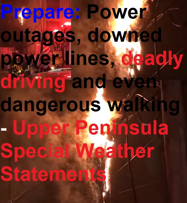
New NWS special snowstorm statements issued this morning: U.P. Winter winds down with a weekend punch – lots of black ice, snow, wind, waves and slippery driving
By Greg Peterson
U.P. Breaking News
Owner, News Director
906-273-2433
(Upper Peninsula of Michigan including Lake Superior) – A major snowstorm will pass through the U.P. this weekend – making driving hazardous with heavy, drifting and blowing snow.
Black ice is a danger the entire weekend including this morning.
A large storm system is moving through the Great Lakes this weekend.
And you would not want to be out in western Lake Superior with 15-foot waves and gusts to nearly 50 mph.
Important NWS Marquette links:
https://www.weather.gov/mqt/
Winter Storm Watch in effect from Saturday, April 14, 7:00 PM CDT until Monday, April 16, 1:00 AM CDT
Winter Storm Watch in effect from tonight Fri., April 13, 8:00 PM EDT until Sat., April 14, 2:00 PM EDT
Winter Storm Warning
Winter Storm Watch
Special Weather Statement
Gale Warning
NWS Marquette Spring 2018 Weather Presentations
Michigan Severe Weather Awareness Week April 8-14
Winter Storm Watch
URGENT - WINTER WEATHER MESSAGE
National Weather Service Marquette MI
427 AM EDT Fri Apr 13 2018

MIZ012-131630-
/O.UPG.KMQT.WS.A.0006.180414T0000Z-180414T1800Z/
/O.NEW.KMQT.WW.Y.0022.180414T0000Z-180414T1200Z/
/O.NEW.KMQT.WS.A.0007.180415T0000Z-180416T0600Z/
Menominee-
Including the city of Menominee
327 AM CDT Fri Apr 13 2018

...WINTER WEATHER ADVISORY IN EFFECT FROM 7 PM THIS EVENING TO
7 AM CDT SATURDAY...
...WINTER STORM WATCH IN EFFECT FROM SATURDAY EVENING THROUGH
LATE SUNDAY NIGHT...

* WHAT...Snow expected tonight. Total snow accumulations of 1 to 3
  inches, with localized amounts up to 5 inches, are expected
  tonight. Saturday night through Sunday evening, heavy snow is
  possible. Total snow accumulations of 8 inches or more are
  possible. The snow may mix with freezing rain Sunday night,
  leading to a light glaze of ice.

* WHERE...Menominee County.

* WHEN...For the Winter Weather Advisory, from 7 PM this evening
  to 7 AM CDT Saturday. For the Winter Storm Watch, from
  Saturday evening through late Sunday night.

* ADDITIONAL DETAILS...Plan on slippery road conditions and
  reduced visibilities at times tonight. Plan on difficult travel
  conditions Saturday night through Sunday night. Winds gusting
  as high as 35 mph could cause areas of blowing and drifting
  snow.

PRECAUTIONARY/PREPAREDNESS ACTIONS...

A Winter Weather Advisory for snow means periods of snow will
cause primarily travel difficulties. Expect snow covered roads
and limited visibilities, and use caution while driving.

A Winter Storm Watch means there is potential for significant
snow, sleet or ice accumulations that may impact travel. Continue
to monitor the latest forecasts.
URGENT - WINTER WEATHER MESSAGE
National Weather Service Marquette MI
427 AM EDT Fri Apr 13 2018

MIZ007-010-085-131630-
/O.NEW.KMQT.WS.A.0007.180415T0000Z-180416T0600Z/
Luce-Iron-Northern Schoolcraft-
Including the cities of Newberry, Iron River, and Seney
427 AM EDT Fri Apr 13 2018 /327 AM CDT Fri Apr 13 2018/

...WINTER STORM WATCH IN EFFECT FROM SATURDAY EVENING THROUGH
LATE SUNDAY NIGHT...

* WHAT...Heavy snow possible. Total snow accumulations of 8 or
  more inches are possible. The snow may mix with freezing rain
  from Seney eastward Sunday night, which may create a thin glaze
  of ice.

* WHERE...Luce, Iron and Northern Schoolcraft Counties.

* WHEN...From Saturday evening through late Sunday night.

* ADDITIONAL DETAILS...Plan on difficult travel conditions.
  Winds gusting as high as 35 mph could cause patchy blowing and
  drifting snow.

PRECAUTIONARY/PREPAREDNESS ACTIONS...

A Winter Storm Watch means there is potential for significant
snow, sleet or ice accumulations that may impact travel. Continue
to monitor the latest forecasts.
Winter Storm Watch
URGENT – WINTER WEATHER MESSAGE
National Weather Service Marquette MI
406 PM EDT Thu Apr 12 2018
MIZ011>014-131000-
/O.NEW.KMQT.WS.A.0006.180414T0000Z-180414T1800Z/
Dickinson-Menominee-Delta-Southern Schoolcraft-
Including the cities of Iron Mountain, Menominee, Escanaba,
Gladstone, and Manistique
406 PM EDT Thu Apr 12 2018 /306 PM CDT Thu Apr 12 2018/
…WINTER STORM WATCH heavy IN EFFECT FROM FRIDAY EVENING THROUGH
SATURDAY AFTERNOON…
* WHAT…Heavy snow possible. Total snow accumulations of 6 inches
or more are possible. The most snow will occur south of US-2.
The snow may mix with rain and sleet early on Friday evening.
* WHERE…Dickinson, Menominee, Delta and Southern Schoolcraft
Counties.
* WHEN…From Friday evening through Saturday afternoon.
* ADDITIONAL DETAILS…Plan on difficult travel conditions.
Significant reductions in visibility are possible due to blowing
and drifting snow.
PRECAUTIONARY/PREPAREDNESS ACTIONS…
A Winter Storm Watch means there is potential for significant
snow, sleet or ice accumulations that may impact travel. Continue
to monitor the latest forecasts.
JLA
Special Weather Statement
Special Weather Statement
National Weather Service Marquette MI
428 PM EDT Thu Apr 12 2018
MIZ011>014-131000-
Dickinson-Menominee-Delta-Southern Schoolcraft-
Including the cities of Iron Mountain, Menominee, Escanaba,
Gladstone, and Manistique
428 PM EDT Thu Apr 12 2018 /328 PM CDT Thu Apr 12 2018/
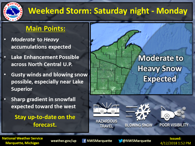
…ANOTHER SYSTEM MAY BRING MORE SNOW LATER THIS WEEKEND…
After the first system producing the potential heavy snow over
south central Upper Michigan Friday into Saturday morning exits
later Saturday, expect another round of moderate to heavy snow to
return to the area Saturday night through Sunday night as a strong
low pressure system lifts across the Great Lakes. Expect snow
amounts Saturday night through Sunday night to range from 5 to 10
inches, heaviest across the east half of Upper Michigan. Locally
higher amounts may occur. The most snow will fall late Saturday
night through Sunday evening. There is still uncertainty on the
track of the storm and these snow totals for Saturday night into
Sunday night may change in the coming days. In addition to the
snow, there could be areas of blowing and drifting snow,
especially later in the weekend.
Please continue to monitor later statements and forecasts for the
latest details concerning this late season winter weather.
URGENT – MARINE WEATHER MESSAGE
National Weather Service Marquette MI
1033 PM EDT Thu Apr 12 2018
LMZ221-248-250-131045-
/O.CON.KMQT.GL.W.0020.180413T1800Z-180415T1200Z/
Green Bay North of line from Cedar River MI to Rock Island
Passage-Seul Choix Point to Point Detour MI-
5NM East of a line from Fairport MI to Rock Island Passage-
1033 PM EDT Thu Apr 12 2018
…GALE WARNING REMAINS IN EFFECT FROM 2 PM FRIDAY TO 8 AM EDT
SUNDAY…
A Gale Warning remains in effect from 2 PM Friday to 8 AM EDT
Sunday.
* WIND AND WAVES DURING THE GALE WARNING…Expect sustained
winds of up to 31 knots from the northeast, with gusts up to
42 knots. The largest expected significant waves will be 10
feet with a maximum wave height of up to 15 feet possible.
* TIMING…The maximum winds are expected around 10 AM EDT
Saturday with the largest waves expected around 10 PM EDT
Saturday.
Please see the latest marine forecasts for more detailed
information.
PRECAUTIONARY/PREPAREDNESS ACTIONS…
A Gale Warning means winds of 34 to 47 knots are imminent or
occurring. Operating a vessel in gale conditions requires
experience and properly equipped vessels. It is highly
recommended that mariners without the proper experience seek safe
harbor prior to the onset of gale conditions.
Special Weather Statement
National Weather Service Marquette MI
428 PM EDT Thu Apr 12 2018
MIZ001>007-009-010-084-085-131000-
Keweenaw-Ontonagon-Northern Houghton-Baraga-Marquette-Alger-Luce-
Gogebic-Iron-Southern Houghton-Northern Schoolcraft-
Including the cities of Copper Harbor, Ontonagon, Houghton,
Hancock, L`Anse, Gwinn, Marquette, Grand Marais, Munising,
Newberry, Ironwood, Iron River, Kenton, Sidnaw, and Seney
428 PM EDT Thu Apr 12 2018 /328 PM CDT Thu Apr 12 2018/
…ACTIVE WINTER WEATHER INTO THE WEEKEND…
A narrow swath of heavy wet snow is expected to develop over
portions of southern Upper Michigan Friday into Friday night out
ahead of a strong deepening low over the central Plains. It still
looks like the heavier snow will stay south of north central Upper
Michigan. Expect snow amounts Friday into Saturday morning to
range from less than 1 inch on the Keweenaw, to 1 to 3 inches
along the rest of Lake Superior, including at Ironwood, Marquette
and Munising, and to 2 to 6 inches over south central Upper
Michigan, heaviest south of US-2. This first round of snow will
end on Saturday.
Another round of moderate to heavy snow is expected Saturday night
through Sunday night as the main low pressure system lifts across
the Great Lakes. Expect snow amounts Saturday night through Sunday
night to range from 5 to 10 inches, heaviest across the east half
of Upper Michigan. Locally higher amounts may occur. The most snow
will fall late Saturday night through Sunday evening. There is
still uncertainty on the track of the storm and these snow totals
may change in the coming days. In addition to the snow, there
could be significant blowing and drifting snow, especially closer
to Lake Superior late in the weekend.
Please continue to monitor later statements and forecasts for the
latest details concerning this late season winter weather.